Peaking Desolation
Desolation Wilderness, 60,000 acres of alpine lakes, granite mountains and wind battered tees. Nestled between Lake Tahoe, California and the foothills, Desolation Wilderness is a fitting name for a protected wilderness with more granite than dirt and isolation befitting its name.
Peaking Desolation or more accurately, hiking to the top of Pyramid Peak located within its boundaries, is something that I had wanted to do for a long time. At 9,985 feet above sea level, it is the highest point around, in my backyard and just a short hour drive away.
Deciding to do this trip now, in October 2013, the area is in-between seasons. Summer hikers are gone, fall is here but snowfall is taking its time, but when it does, brings hoards of skiers and snowboarders up to the mountains. In the meantime this makes the area ripe for uncrowded adventures. It’s a nice lull between the busy seasons that makes Desolation Wilderness a beautiful, quiet place to go on a day hike or spend a week backpacking from alpine lake to alpine lake.
We (my brother and I) had decided awhile ago that short backpacking trips, a night or two, was something we needed to do more often. Ones that don’t take a lot of pre-planning and preparation. A couple months back we did two nights in Point Reyes National Seashore with family members. I had been there many times before and it’s still a magical place that few visit. Imagine a beach, miles long that has unobstructed views of the ocean, small boats motoring about and amazing sunsets that only a handful of people see every night, oh and you can only get to by hiking 5 or more miles in.
It’s hard to beat.
We decided this trip into Desolation Wilderness, to peak the Pyramid was a fairly easy overnighter, with 12 miles total hiking. Nothing crazy and it didn’t need to be. Bagging pyramid peak was the prize, not monster mileage.
The day started late in the morning, the car was packed with gear, rum was purchased and 3 guys were ready to conquer. “It’s going to be a full moon tonight” I say to my fellow backpackers, my brother Matt and our friend J as we made our way up Highway 50, passing the lines of cars waiting to get to Apple Hill, a destination of apples and Christmas trees. “Cold too, low of 31 degrees.” The weather looked like it was going to be great, just a bit cold at night.
The hour long ride took us up Highway 50 and off on the winding, narrow roads of the El Dorado National Forrest. Paved yes, smooth, not so much. By the time we got to the Lyons Creek Trailhead, cars had already started filling up the small lot. Either from that day or other overnighters, already deep into the wilderness.
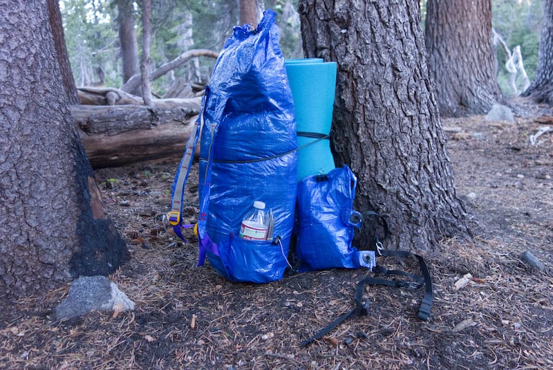
It was 11am when we hit the trailhead, packs loaded to capacity. I was testing a pack I made myself. This was a good test hike because if the pack had failed completely, I wasn’t too far from the car and if I had to carry the pack awkwardly, it could be done for the few miles we were hiking.
We walked the trail, slowly climbing 1,300 feet through pines, low dry brush and large chunks of granite rock outcroppings. We had 4.5 miles to reach Lake Sylvia and it went quickly as conversation flowed easily. We only passed two groups the entire way up. What was surprising to me as we hiked was how dry everything was, the trail followed Lyons Creek, which wasn’t flowing and only had a few pools here and there. Overall, very desolate.
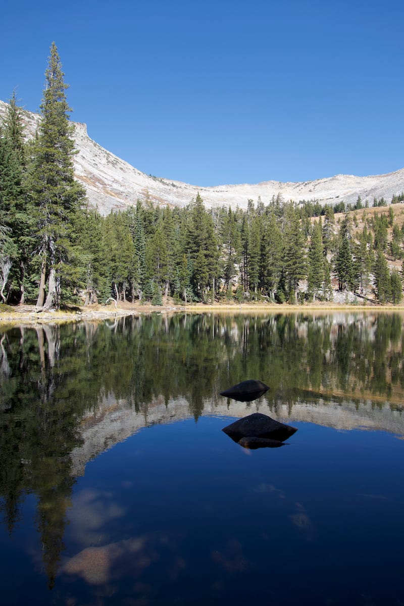
After taking a couple rest breaks for food and water, we had made it to the lake. Taking roughly 2 hours to get there, it was a site to see. Nestled in a bowl, consisting of trees and brown grasses, Lake Sylvia is a clear, cold body of water reflecting the mountains surrounding us. We found a spot to put our packs down, rest and eat some lunch before tackling the last mile, a 2,000 foot climb to the top. Since we were camping here, we were able to leave our packs and just took water. Carrying packs up this last mile is possible, but not recommended.
We started scrambling on the very vertical looking bowl up to a notch to the ridge. The rocks we were climbing became increasingly smaller. Near the top there was a slippery mix of dirt and scree. I probably looked like a graceless monkey on my hands and feet going from rock to rock, trying to find ones still embedded firmly into the side.
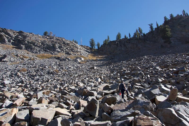
Taking a breather at the top we looked towards our next destination. The ridge above and to the left of us. There is no official trail heading up to the peak but over time people had been placing rock cairns or markers showing a way up. But really, you basically just picked a route that looked the easiest and safest. It was steep! If we weren’t going over large boulders we were walking up loose dirt and rocks. The grade made us stop every 15-20 steps to let the burn in our legs subside and catch our breath.
When we got to the top of the second ridge, we were surprised at how far we still had to go. In front of us, we saw the top of the peak, hundreds of feet higher and further than where we were. We made out small moving specs at the top, people that had started making their way up to the top before us. We had to laugh at the distance we still had to cover. We looked down below at the landmarks that were much closer an hour ago and out at how much more we could already see, even though we weren’t at the top yet. We pressed on.
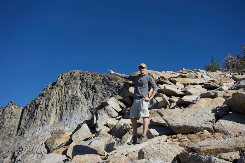
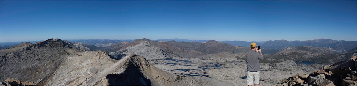
Victory! We had made it! Over 9,900 feet high, we were at the top. After scrambling for a couple hours, we were finally able to take a good long rest and take in the view. We could see Lake Tahoe in the distance and the many lakes inside Desolation Wilderness. Even the route we took while on the PCT in 2012. There was even cell signal and I proceeded to take a picture of our success and post it on the internet. Technology in the wilderness is great sometimes.
Twenty minutes later we had taken enough photos and recouped enough to head back down. It was 1:30 when we started our way up from the lake and 4 o’clock when started our careful decent back down.
The way down was quick and fairly easy, until we got to the notch, the last steep section before getting back to our packs, food and rest. This section was by far the sketchiest part. Because of how steep it was, combined with the loose rocks made for a slow and slightly nerve-wracking climb down.
It only took an hour to get back down and we recovered right near the shore of the Lake before moving to a flat spot to set up camp.
Camp was a nice flat spot surrounded by trees which provided a good wind block if the wind decided to kick up. After we set up our shelters, the hunger hit and the sun had gone behind the mountains, making the chilly air start to creep into me. I put on my nice, warm, burnt orange, puffy aka down jacket and my buff before getting ready to make some food.
The rum we packed in was poured and a celebratory toast was had. On the menu was beef stew and chicken teriyaki, both freeze dried hiking meals. So a quick boiling of water and 10 minutes of rehydration, good hot food was filling our bellies. Eating by headlamp and drinking rum helped keep the cold out.
After dinner we walked over to the lake, sitting on the edge and looking out, with the remaining glow of light in the sky, illuminating across the water. It was nice to sit and enjoy the view after a day of hard work.
Returning to camp and continuing to work on the bottle of rum, everyones tiredness became apparent. It was decided, we would get into our sleeping bags and call it a night. It was just past 7pm.
The way I had set up my shelter, my head could poke out and I could watch the full moon rise and light up the entire area. It was as if someone had a giant spotlight pointed right at us. It was also quiet. If you held your breath, you’d hear nothing. The woods around us were silent and the wind was still. Silence like that is hard to come by these days.
The temperatures that night were not as cold as I thought they would be. I had many more layers of clothing at my disposal to keep me warm but they were not needed. In the morning we slowly started to get up, making oatmeal and coffee. Warm things on cold mornings are nice. People that say stoves are too heavy to bring are crazy!
Packing everything up, we hit the trail at 9 to make the 4.5 mile hike back to the car. It was downhill, making for a fast hike. The surrounding landscape looked foreign though. It was the way we had come in, but it looked very unfamiliar. I guess we were so wrapped up in conversation, that we didn’t take in a lot of detail.
A cheer of success was had as we got in view of the car. Loading our much lighter packs back into the trunk, we started the trip home. I’m glad this short trip was a success. The goal to reach the top of the peak was accomplished and a good, challenging time was had by all.
The backpack I made myself worked great. It didn’t break or tear and was fairly comfortable. A successful test and it gives me confidence that I can make the next one even better.
After Peaking Desolation, I want more. I want to go higher. 9,900 feet is nice and all but I can and want to go much much higher.
First written in 2013 for an old defunct blog. Refreshed and republished for 2024.